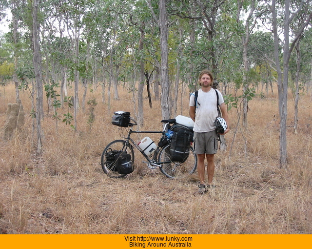
Biking Around Australia
Between February 2002 and March 2003 I circumnavigated 12,504 miles around the Australian continent on my bicycle, or push bike as they say there. After
that I went to New Zealand for three months and met up with a friend and ended up pushing the total mileage to 14,115.7 miles (22717.02 km). I
spent 269 days on my bike, 272 days not on my bike, and getting 67 flat tires over those 17 months.
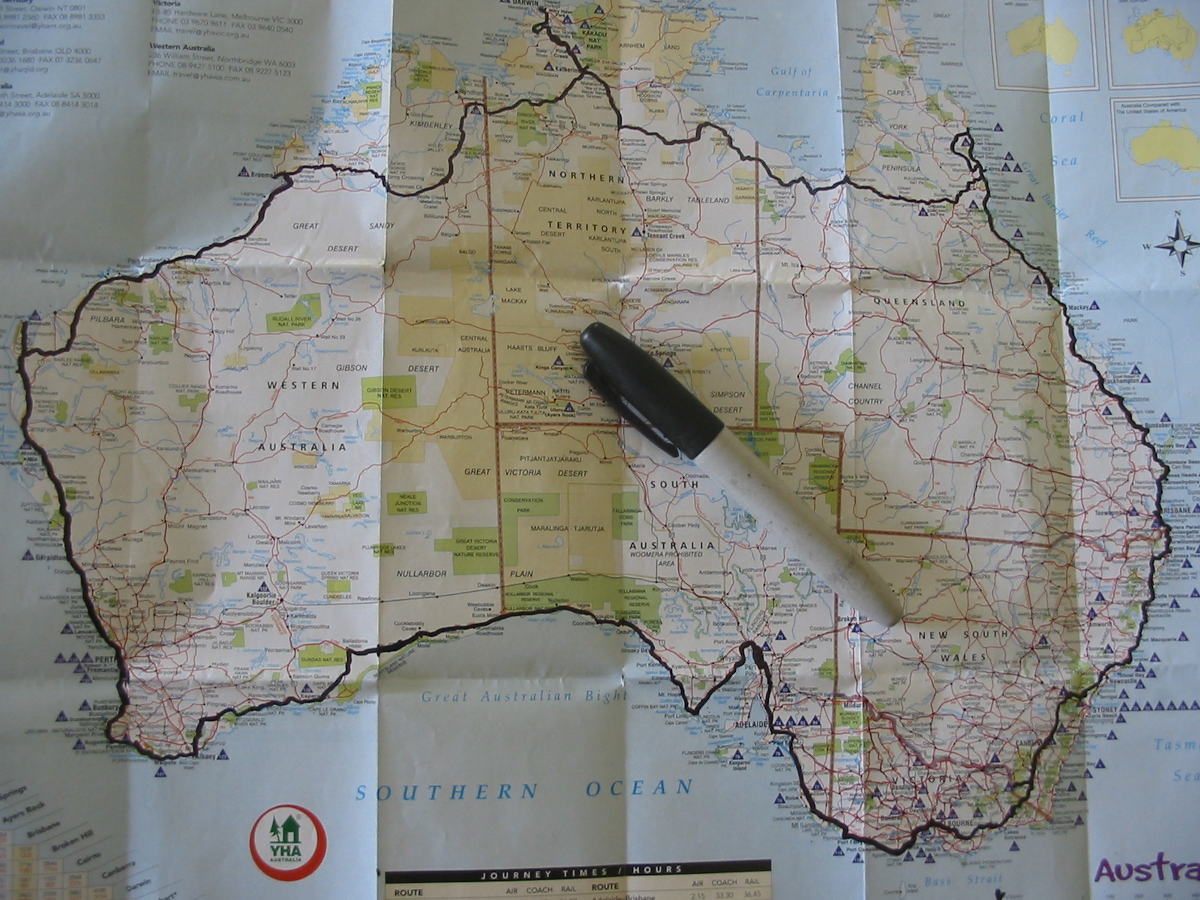
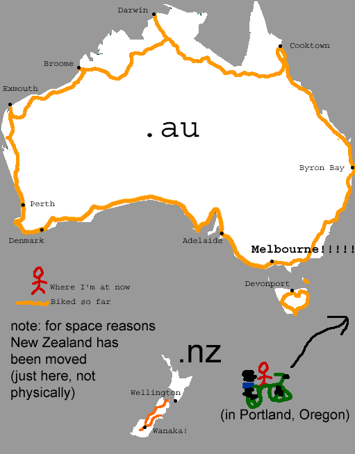
This is the route I took around Australia. Every few days I would update this YHA map with a marker and the route I more or less made up as I went along.
•••
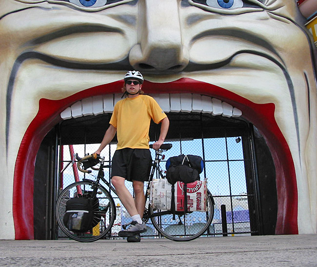
I started and ended my 13 month lap around Australia at Luna Park in St. Kilda/Melbourne.. The distance around
Australia (including Tasmania) ended up being about 20,281km (12,600 miles).
February 12th, 2002 - 3:50pm
March 12th, 2003 - 3:12pm
•••
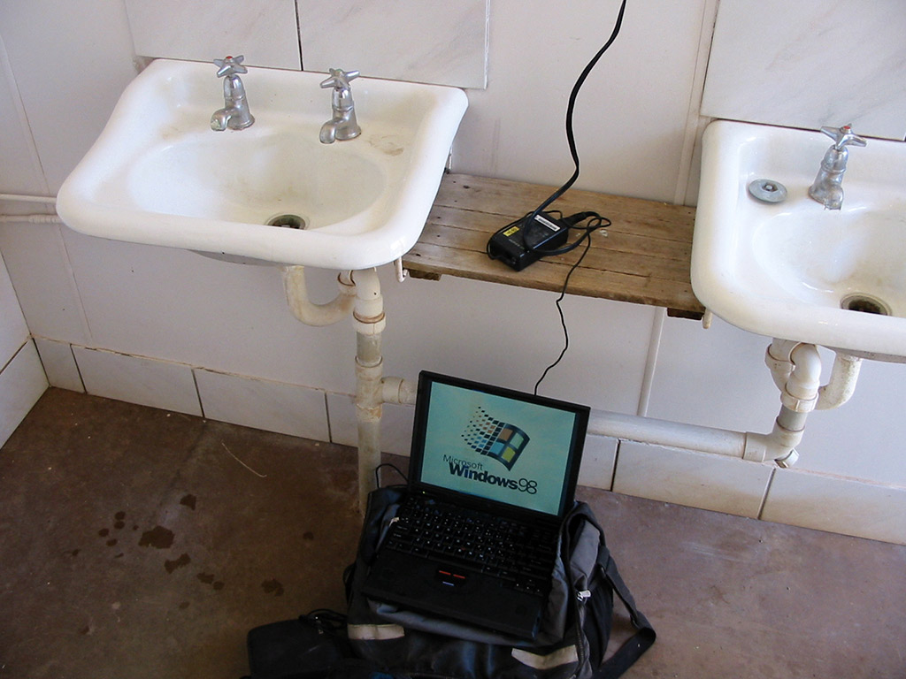
I carried a 15 pound IBM Thinkpad 600E with five batteries over the course of the entire trip in order to keep this website updated on a weekly basis so people back home could follow me on my travels. I
had a system setup where I'd back the photos up to CDs and mail them home every few weeks. To update the site, I primarily did it with 3.5 inch floppy disks.
There are 542 daily journal entries on here. I redid the website in 2020 so it would show up on phones and such ok.
I took 36,304 photos over the 17 months and 12321 of them ended up here on this website. As for the words, there are 119543 of them for you to read. I didn't start active journaling until a couple months into the journey. I've
noted where I've added journal entries way after the fact based on recollections or notes I had from the time. Some people have actually read the the entire site and have seen every picture. Some entries were written the same day, others were not. Some entires are a thought-provoking and a wholly entertaining read, others are downright boring.
Lunky.com website 2001-2020
The MS Paint image I updated every few days
•••
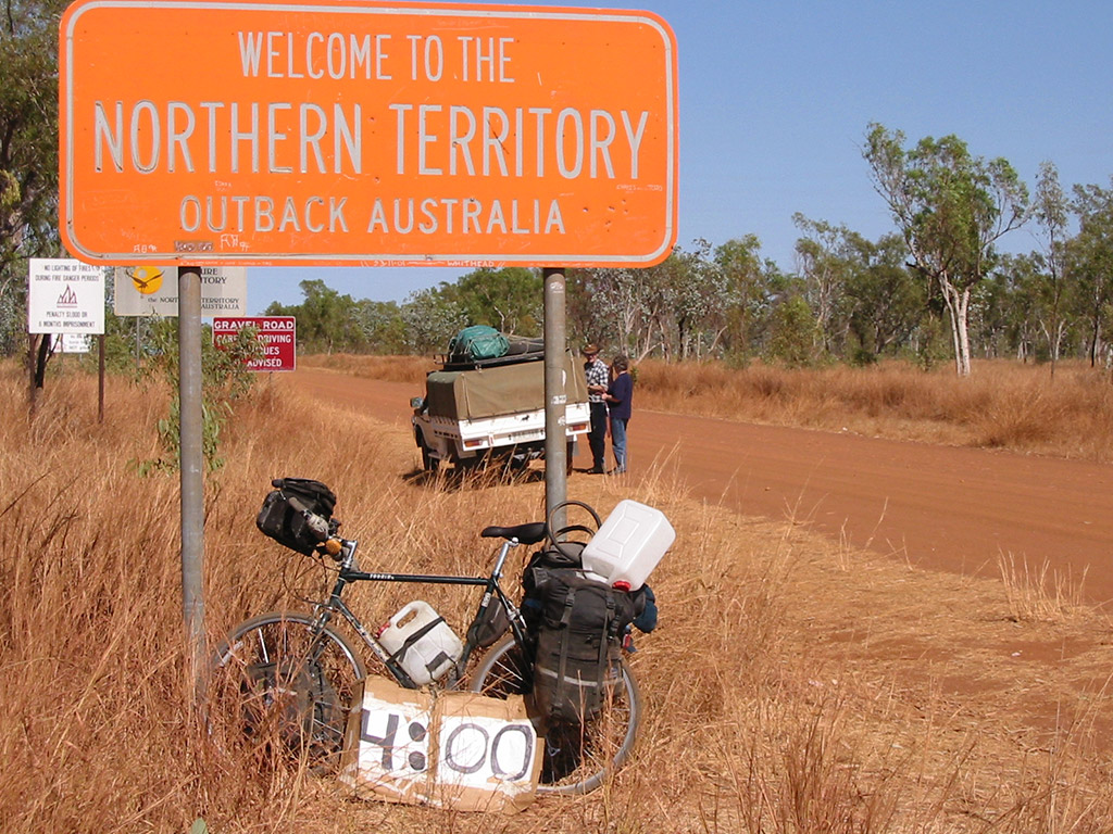
Also during the journey I carried a cardboard "clock" for this website I had started a year earlier called
The Human Clock . Here
it is on the Queensland/Northern Territory border
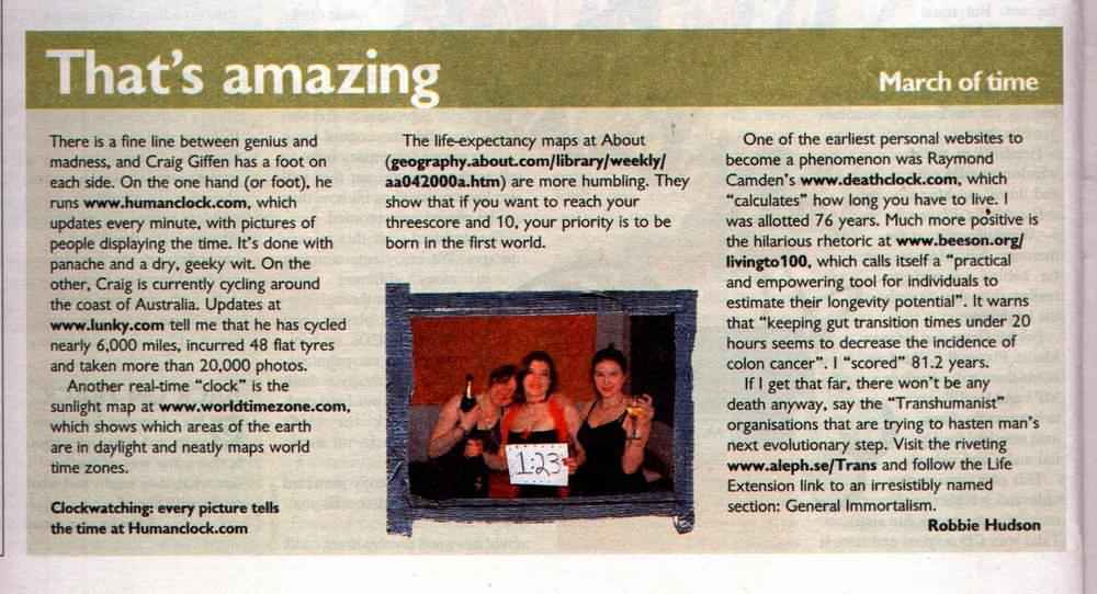
The Human Clock website was pretty popular then and it plus my bike trip got a quick blurb in the Sunday Times of London in September of 2002
•••
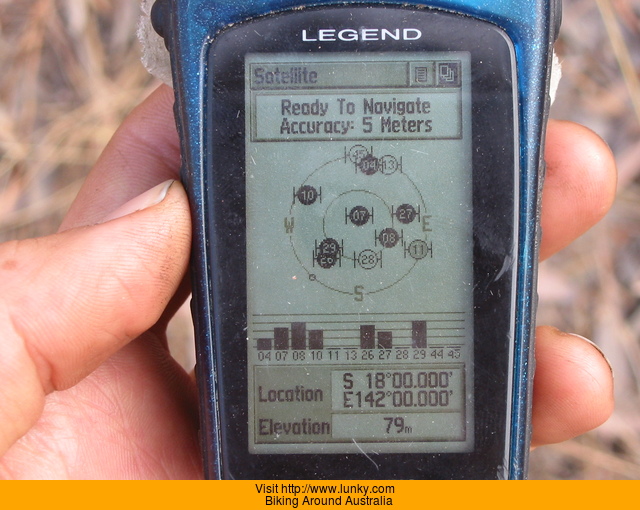
One fun thing I did during my trip was to visit six "confluences" , which
is where a whole-numbered latitude/longitude mark intersects for The Degree Confluence Project.
This was also back when the GPS looked nice
Thanks for reading!
USA: 0.00mi | 2002-2-01 Introduction / Leave Home
USA: 0.00mi | 2002-2-02 vaporized day
USA: 0.00mi | 2002-2-03 Los Angeles -> Malaysia
VIC: 25.60mi | 2002-2-04 Los Angeles -> Malaysia to Melbourne / St. Kilda
VIC: 25.60mi | 2002-2-05 Melbourne / St. Kilda
VIC: 25.60mi | 2002-2-06 Melbourne / St. Kilda
VIC: 38.00mi | 2002-2-07 Melbourne / St. Kilda to Melbourne / St. Kilda
VIC: 38.00mi | 2002-2-08 Melbourne / St. Kilda
VIC: 38.00mi | 2002-2-09 Melbourne / St. Kilda
VIC: 38.00mi | 2002-2-10 Melbourne / St. Kilda
VIC: 38.00mi | 2002-2-11 Melbourne / St. Kilda
VIC: 38.00mi | 2002-2-12 Melbourne / St. Kilda
VIC: 41.10mi | 2002-2-13 Melbourne / St. Kilda to Spirit of Tasmania ferry
TAS: 51.60mi | 2002-2-14 Spirit of Tasmania ferry to Devonport
TAS: 57.80mi | 2002-2-15 Devonport to Devonport
TAS: 62.80mi | 2002-2-16 Devonport to Devonport
TAS: 109.20mi | 2002-2-17 Devonport to Launceston
TAS: 109.20mi | 2002-2-18 Launceston
TAS: 124.60mi | 2002-2-19 Launceston to Near Lilydale
TAS: 150.90mi | 2002-2-20 Near Lilydale to Scottsdale
TAS: 159.00mi | 2002-2-21 Scottsdale to Bridport
TAS: 159.00mi | 2002-2-22 Bridport
TAS: 196.20mi | 2002-2-23 Bridport to Bridport / Bellingham
TAS: 196.20mi | 2002-2-24 Bridport
TAS: 196.20mi | 2002-2-25 Furneaux Freight boat
TAS: 217.10mi | 2002-2-26 Furneaux Freight boat to Walkers Lookout
TAS: 232.40mi | 2002-2-27 Walkers Lookout to Wybalenna
TAS: 242.90mi | 2002-2-28 Wybalenna to Whitemark Flinders Island
TAS: 242.90mi | 2002-3-01 Whitemark Flinders Island
TAS: 249.40mi | 2002-3-02 Whitemark Flinders Island to Trousers Point
TAS: 252.50mi | 2002-3-03 Trousers Point to Trousers Point
TAS: 280.80mi | 2002-3-04 Trousers Point to Northeast River
TAS: 280.90mi | 2002-3-05 Northeast River to Northeast River
TAS: 302.40mi | 2002-3-06 Northeast River to Allports Beach
TAS: 321.00mi | 2002-3-07 Allports Beach to Lady Baron
TAS: 321.00mi | 2002-3-08 Bridport
TAS: 321.00mi | 2002-3-09 Bridport
TAS: 321.00mi | 2002-3-10 Bridport
TAS: 321.00mi | 2002-3-11 Bridport
TAS: 321.00mi | 2002-3-12 Bridport
TAS: 321.00mi | 2002-3-13 Bridport
TAS: 321.00mi | 2002-3-14 Bridport
TAS: 321.00mi | 2002-3-15 Bridport / Scottsdale
TAS: 321.00mi | 2002-3-16 Bridport
TAS: 321.00mi | 2002-3-17 Bridport
TAS: 321.00mi | 2002-3-18 Bridport
TAS: 376.40mi | 2002-3-19 Bridport to Ansons Bay
TAS: 402.90mi | 2002-3-20 Ansons Bay to St. Helens
TAS: 452.80mi | 2002-3-21 St. Helens to Bicheno
TAS: 512.10mi | 2002-3-22 Bicheno to Triabunna
TAS: 514.00mi | 2002-3-23 Triabunna to Triabunna
TAS: 570.80mi | 2002-3-24 Triabunna to Hobart
TAS: 610.00mi | 2002-3-25 Hobart to Port Huon
TAS: 637.10mi | 2002-3-26 Port Huon to Dover
TAS: 676.50mi | 2002-3-27 Dover to Southern Tip of Tasmania
TAS: 713.70mi | 2002-3-28 Southern Tip of Tasmania to Geevston
TAS: 752.80mi | 2002-3-29 Geevston to Hobart
TAS: 759.00mi | 2002-3-30 Hobart to Hobart
TAS: 806.60mi | 2002-3-31 Hobart to Mt. Field NP
TAS: 832.10mi | 2002-4-01 Mt. Field NP to Ouze
TAS: 867.10mi | 2002-4-02 Ouze to near Lake Sinclair
TAS: 925.10mi | 2002-4-03 near Lake Sinclair to Lake Burbury
TAS: 940.00mi | 2002-4-04 Lake Burbury to Queenstown
TAS: 968.30mi | 2002-4-05 Queenstown to Strahan
TAS: 1018.50mi | 2002-4-06 Strahan to south of Tullah
TAS: 1072.50mi | 2002-4-07 south of Tullah to Cradle Mountain
TAS: 1120.50mi | 2002-4-08 Cradle Mountain to Devonport
TAS: 1120.50mi | 2002-4-09 Devonport
TAS: 1120.50mi | 2002-4-10 Launceston
TAS: 1120.50mi | 2002-4-11 Bridport
TAS: 1120.50mi | 2002-4-12 Port Sorell
TAS: 1120.50mi | 2002-4-13 Port Sorell / ferry over Bass Strait
VIC: 1129.80mi | 2002-4-14 Port Sorell / ferry over Bass Strait to Melbourne / Coburg
VIC: 1136.00mi | 2002-4-15 Melbourne / Coburg to Melbourne / Coburg
VIC: 1136.00mi | 2002-4-16 Melbourne / Coburg
VIC: 1136.00mi | 2002-4-17 Melbourne / Coburg
VIC: 1142.20mi | 2002-4-18 Melbourne / Coburg to Melbourne / Coburg
VIC: 1142.20mi | 2002-4-19 Melbourne / Coburg
VIC: 1142.20mi | 2002-4-20 Melbourne / Coburg
VIC: 1191.80mi | 2002-4-21 Melbourne / Coburg to Beaconsfield
VIC: 1236.10mi | 2002-4-22 Beaconsfield to Warragul
VIC: 1295.80mi | 2002-4-23 Warragul to Heyfield
VIC: 1369.60mi | 2002-4-24 Heyfield to Bairnsdale
VIC: 1414.20mi | 2002-4-25 Bairnsdale to Buchan
VIC: 1415.80mi | 2002-4-26 Buchan to Buchan
VIC: 1462.90mi | 2002-4-27 Buchan to Te Anau
VIC: 1501.30mi | 2002-4-28 Te Anau to Kosciuszko NP
VIC: 1586.50mi | 2002-4-29 Kosciuszko NP to Jindabyne
VIC: 1611.90mi | 2002-4-30 Jindabyne to Berridale
ACT: 1665.80mi | 2002-5-01 Berridale to NSW/ACT Border
ACT: 1726.10mi | 2002-5-02 NSW/ACT Border to Canberra
ACT: 1739.10mi | 2002-5-03 Canberra to Canberra
NSW: 1800.80mi | 2002-5-04 Canberra to Goulburn
NSW: 1832.40mi | 2002-5-05 Goulburn to Taralga
NSW: 1865.30mi | 2002-5-06 Taralga to south of Porters Retreat
NSW: 1905.50mi | 2002-5-07 south of Porters Retreat to Jenolan Caves
NSW: 1953.00mi | 2002-5-08 Jenolan Caves to Bell
NSW: 1990.80mi | 2002-5-09 Bell to Richmond
NSW: 1990.80mi | 2002-5-10 Sydney
NSW: 1990.80mi | 2002-5-11 Sydney
NSW: 1990.80mi | 2002-5-12 Glebe / Sydney
NSW: 1990.80mi | 2002-5-13 Glebe / Sydney
NSW: 1990.80mi | 2002-5-14 Glebe / Sydney
NSW: 1990.80mi | 2002-5-15 Glebe / Sydney
NSW: 1990.80mi | 2002-5-16 Glebe / Sydney
NSW: 1990.80mi | 2002-5-17 Glebe / Sydney
NSW: 1990.80mi | 2002-5-18 Glebe / Sydney
NSW: 1990.80mi | 2002-5-19 Glebe / Sydney
NSW: 1990.80mi | 2002-5-20 Glebe / Sydney
NSW: 1990.80mi | 2002-5-21 Glebe / Sydney
NSW: 1990.80mi | 2002-5-22 Glebe / Sydney
NSW: 1990.80mi | 2002-5-23 Glebe / Sydney
NSW: 1990.80mi | 2002-5-24 Glebe / Sydney
NSW: 1990.80mi | 2002-5-25 Glebe / Sydney
NSW: 1990.80mi | 2002-5-26 Glebe / Sydney
NSW: 1990.80mi | 2002-5-27 Glebe / Sydney
NSW: 2020.60mi | 2002-5-28 Glebe / Sydney to Hornsby
NSW: 2077.80mi | 2002-5-29 Hornsby to Bucketty
NSW: 2134.80mi | 2002-5-30 Bucketty to Maitland
NSW: 2189.50mi | 2002-5-31 Maitland to Girvan
NSW: 2189.50mi | 2002-6-01 Girvan
NSW: 2244.10mi | 2002-6-02 Girvan to Forester
NSW: 2308.90mi | 2002-6-03 Forester to Lake Cathie
NSW: 2355.50mi | 2002-6-04 Lake Cathie to Kempsey
NSW: 2393.30mi | 2002-6-05 Kempsey to north of Grassy Head
NSW: 2433.60mi | 2002-6-06 north of Grassy Head to Bellingen
NSW: 2433.60mi | 2002-6-07 Bellingen
NSW: 2433.60mi | 2002-6-08 Bellingen
NSW: 2433.60mi | 2002-6-09 Bellingen
NSW: 2461.30mi | 2002-6-10 Bellingen to Coffs Harbor
NSW: 2519.60mi | 2002-6-11 Coffs Harbor to Grafton
NSW: 2583.70mi | 2002-6-12 Grafton to Casino
NSW: 2630.50mi | 2002-6-13 Casino to Byron Bay
NSW: 2630.50mi | 2002-6-14 Byron Bay
NSW: 2630.50mi | 2002-6-15 Byron Bay
QLD: 2703.80mi | 2002-6-16 Byron Bay to Surfers Paradise
QLD: 2770.50mi | 2002-6-17 Surfers Paradise to Brisbane
QLD: 2789.10mi | 2002-6-18 Brisbane to Brisbane
QLD: 2789.10mi | 2002-6-19 Ashgrove / Brisbane
QLD: 2789.10mi | 2002-6-20 Ashgrove / Brisbane
QLD: 2789.10mi | 2002-6-21 Ashgrove / Brisbane
QLD: 2795.30mi | 2002-6-22 Ashgrove / Brisbane to Ashgrove / Brisbane
QLD: 2858.80mi | 2002-6-23 Ashgrove / Brisbane to Landsborough
QLD: 2889.20mi | 2002-6-24 Landsborough to Bli Bli
QLD: 2938.90mi | 2002-6-25 Bli Bli to south of Rainbow Beach
QLD: 2962.20mi | 2002-6-26 south of Rainbow Beach to Rainbow Beach
QLD: 3027.90mi | 2002-6-27 Rainbow Beach to Maryborough
QLD: 3068.80mi | 2002-6-28 Maryborough to Childers
QLD: 3133.30mi | 2002-6-29 Childers to Yandaran
QLD: 3166.40mi | 2002-6-30 Yandaran to Lowmead
QLD: 3166.40mi | 2002-7-01 Lowmead
QLD: 3245.20mi | 2002-7-02 Lowmead to Gladstone
QLD: 3318.70mi | 2002-7-03 Gladstone to Rockhampton
QLD: 3324.90mi | 2002-7-04 Rockhampton to Rockhampton
QLD: 3324.90mi | 2002-7-05 Rockhampton / Emu Park
QLD: 3329.90mi | 2002-7-06 Rockhampton / Emu Park to Emu Park
QLD: 3329.90mi | 2002-7-07 Emu Park
QLD: 3399.30mi | 2002-7-08 Emu Park to Marlborough
QLD: 3464.70mi | 2002-7-09 Marlborough to The Hamburger Hut
QLD: 3534.50mi | 2002-7-10 The Hamburger Hut to Sarina
QLD: 3561.30mi | 2002-7-11 Sarina to Mackay
QLD: 3567.50mi | 2002-7-12 Mackay to Mackay
QLD: 3633.80mi | 2002-7-13 Mackay to 20k south of Proserpine
QLD: 3696.40mi | 2002-7-14 20k south of Proserpine to Bowen
QLD: 3696.40mi | 2002-7-15 Bowen
QLD: 3765.70mi | 2002-7-16 Bowen to Home Hill
QLD: 3845.70mi | 2002-7-17 Home Hill to Townsville
QLD: 3910.20mi | 2002-7-18 Townsville to Ingham
QLD: 3974.10mi | 2002-7-19 Ingham to Tully
QLD: 4049.70mi | 2002-7-20 Tully to Gordonvale
QLD: 4069.50mi | 2002-7-21 Gordonvale to Cairns
QLD: 4082.80mi | 2002-7-22 Cairns to Cairns
QLD: 4095.20mi | 2002-7-23 Cairns to Cairns
QLD: 4136.70mi | 2002-7-24 Cairns to Mareeba
QLD: 4238.10mi | 2002-7-25 Mareeba to Palmer River Roadhouse
QLD: 4238.10mi | 2002-7-26 Palmer River Roadhouse
QLD: 4238.10mi | 2002-7-27 Palmer River Roadhouse
QLD: 4288.90mi | 2002-7-28 Palmer River Roadhouse to 50k sw of Cooktown
QLD: 4325.50mi | 2002-7-29 50k sw of Cooktown to Cooktown
QLD: 4359.60mi | 2002-7-30 Cooktown to Cedar Bay NP
QLD: 4397.40mi | 2002-7-31 Cedar Bay NP to Cape Tribulation
QLD: 4440.80mi | 2002-8-01 Cape Tribulation to Mossman
QLD: 4489.20mi | 2002-8-02 Mossman to Cairns
QLD: 4489.20mi | 2002-8-03 Cairns
QLD: 4489.20mi | 2002-8-04 Cairns
QLD: 4489.20mi | 2002-8-05 Cairns
QLD: 4489.20mi | 2002-8-06 Pacific Ocean
QLD: 4489.20mi | 2002-8-07 Pacific Ocean near Cairns
QLD: 4489.20mi | 2002-8-08 Pacific Ocean near Cairns
QLD: 4489.20mi | 2002-8-09 Cairns
QLD: 4499.10mi | 2002-8-10 Cairns
QLD: 4558.00mi | 2002-8-11 Cairns to Yungabarra
QLD: 4607.60mi | 2002-8-12 Yungabarra to somewhere north of Mt. Garnet
QLD: 4660.30mi | 2002-8-13 somewhere north of Mt. Garnet to 30k w of Mt Garnet
QLD: 4737.80mi | 2002-8-14 30k w of Mt Garnet to w of Mt. Suprise
QLD: 4811.00mi | 2002-8-15 w of Mt. Suprise to w of Georgetown
QLD: 4906.90mi | 2002-8-16 w of Georgetown to w of Croydon
QLD: 4990.60mi | 2002-8-17 w of Croydon to Normanton
QLD: 4990.60mi | 2002-8-18 Normanton
QLD: 5052.00mi | 2002-8-19 Normanton to 120k e of Burketown
QLD: 5137.60mi | 2002-8-20 120k e of Burketown to Burketown
QLD: 5137.60mi | 2002-8-21 Burketown
QLD: 5212.60mi | 2002-8-22 Burketown to w of Doomadgee
QLD: 5275.00mi | 2002-8-23 w of Doomadgee to 30k e of NT/QLD border
QLD: 5318.40mi | 2002-8-24 30k e of NT/QLD border to 30k w of NT/QLD border
NT: 5392.80mi | 2002-8-25 30k w of NT/QLD border to 100k se of Borroloola
NT: 5462.20mi | 2002-8-26 100k se of Borroloola to Borroloola
NT: 5536.00mi | 2002-8-27 Borroloola to Cape Crawford
NT: 5622.80mi | 2002-8-28 Cape Crawford to 130k e of HiWay Roadhouse
NT: 5704.00mi | 2002-8-29 130k e of HiWay Roadhouse to HiWay Roadhouse
NT: 5768.20mi | 2002-8-30 HiWay Roadhouse to Larrimah
NT: 5816.20mi | 2002-8-31 Larrimah to Matarranka
NT: 5882.80mi | 2002-9-01 Matarranka to Kathernie
NT: 5882.80mi | 2002-9-02 Katherine
NT: 5902.60mi | 2002-9-03 Katherine to Nitmiluk NP
NT: 5902.60mi | 2002-9-04 Nitmiluk NP
NT: 5902.60mi | 2002-9-05 Nitmiluk NP
NT: 5960.40mi | 2002-9-06 Nitmiluk NP to Pine Creek
NT: 5960.40mi | 2002-9-07 Pine Creek
NT: 5996.20mi | 2002-9-08 Pine Creek to Hayes Creek
NT: 6058.90mi | 2002-9-09 Hayes Creek to Batchelor
NT: 6082.70mi | 2002-9-10 Batchelor to Litchfield NP
NT: 6110.90mi | 2002-9-11 Litchfield NP to 10k n of Wangi Falls
NT: 6152.40mi | 2002-9-12 10k n of Wangi Falls to Tumble River Caravan Park
NT: 6185.00mi | 2002-9-13 Tumble River Caravan Park to Palmerston
NT: 6209.80mi | 2002-9-14 Palmerston to Darwin
NT: 6209.80mi | 2002-9-15 Darwin
NT: 6222.20mi | 2002-9-16 Darwin to Darwin
NT: 6234.60mi | 2002-9-17 Darwin to Darwin
NT: 6247.00mi | 2002-9-18 Darwin to Darwin
NT: 6284.90mi | 2002-9-19 Darwin to Noonamah
NT: 6356.60mi | 2002-9-20 Noonamah to 35k n of Hayes Creek
NT: 6426.50mi | 2002-9-21 35k n of Hayes Creek to 25k s of Pine Creek
NT: 6471.30mi | 2002-9-22 25k s of Pine Creek to Katherine
NT: 6471.30mi | 2002-9-23 Katherine
NT: 6471.30mi | 2002-9-24 Katherine
NT: 6512.50mi | 2002-9-25 Katherine to 66k sw of Katherine
NT: 6576.80mi | 2002-9-26 66k sw of Katherine to 35k e of River
NT: 6641.80mi | 2002-9-27 35k e of River to 15k e of Timber Creek
NT: 6652.90mi | 2002-9-28 15k e of Timber Creek to Timber Creek
NT: 6723.20mi | 2002-9-29 Timber Creek to 113w of Timber Creek
NT: 6791.90mi | 2002-9-30 113w of Timber Creek to 10k e of Kununurra
WA: 6800.20mi | 2002-10-01 10k e of Kununurra to Kununarra
WA: 6816.20mi | 2002-10-02 Kununarra to 25k w of Kununarra
WA: 6877.30mi | 2002-10-03 25k w of Kununarra to Doon Doon
WA: 6935.30mi | 2002-10-04 Doon Doon to Warmun
WA: 7003.50mi | 2002-10-05 Warmun to 55k n of Halls Creek
WA: 7039.10mi | 2002-10-06 55k n of Halls Creek to Halls Creek
WA: 7039.10mi | 2002-10-07 Halls Creek
WA: 7109.20mi | 2002-10-08 Halls Creek to Mary Pool Rest Stop
WA: 7201.00mi | 2002-10-09 Mary Pool Rest Stop to 45k e of Fitzroy Crossing
WA: 7228.90mi | 2002-10-10 45k e of Fitzroy Crossing to Fitzroy Crossing
WA: 7228.90mi | 2002-10-11 Fitzroy Crossing
WA: 7228.90mi | 2002-10-12 Fitzroy Crossing
WA: 7294.60mi | 2002-10-13 Fitzroy Crossing to 93k w of FC
WA: 7356.00mi | 2002-10-14 93k w of FC to 40km e of Willare Roadhouse
WA: 7417.60mi | 2002-10-15 40km e of Willare Roadhouse to 110k e of Broome
WA: 7486.00mi | 2002-10-16 110k e of Broome to Broome
WA: 7486.00mi | 2002-10-17 Broome
WA: 7486.00mi | 2002-10-18 Broome
WA: 7486.00mi | 2002-10-19 Broome
WA: 7486.00mi | 2002-10-20 Broome
WA: 7486.00mi | 2002-10-21 Broome
WA: 7486.00mi | 2002-10-22 Broome
WA: 7486.00mi | 2002-10-23 Broome
WA: 7486.00mi | 2002-10-24 Broome
WA: 7486.00mi | 2002-10-25 Broome
WA: 7544.00mi | 2002-10-26 Broome to s of Roebuck Roadhouse
WA: 7623.30mi | 2002-10-27 s of Roebuck Roadhouse to 105k n of Sandfire Roadhouse
WA: 7690.50mi | 2002-10-28 105k n of Sandfire Roadhouse to Sandfire Roadhouse
WA: 7789.70mi | 2002-10-29 Sandfire Roadhouse to 30k sw of Pardoo Roadhouse
WA: 7845.40mi | 2002-10-30 30k sw of Pardoo Roadhouse to 45k e of Port Hedland
WA: 7883.00mi | 2002-10-31 45k e of Port Hedland to Port Hedland
WA: 7883.00mi | 2002-11-01 Port Hedland
WA: 7928.40mi | 2002-11-02 Port Hedland to 60k sw of PH
WA: 7999.70mi | 2002-11-03 60k sw of PH to 30k e of Roebourne
WA: 8047.40mi | 2002-11-04 30k e of Roebourne to Karratha
WA: 8047.40mi | 2002-11-05 Karratha
WA: 8103.20mi | 2002-11-06 Karratha to Karratha
WA: 8130.50mi | 2002-11-07 Karratha to 40k w of Karratha
WA: 8195.60mi | 2002-11-08 40k w of Karratha to 30k w of Fortescue Roadhouse
WA: 8280.60mi | 2002-11-09 30k w of Fortescue Roadhouse to Nanutarra Roadhouse
WA: 8315.70mi | 2002-11-10 Nanutarra Roadhouse to 56k southward
WA: 8387.20mi | 2002-11-11 56k southward to 30k e of Exmouth Turnoff
WA: 8460.50mi | 2002-11-12 30k e of Exmouth Turnoff to Exmouth
WA: 8466.70mi | 2002-11-13 Exmouth to Exmouth
WA: 8466.70mi | 2002-11-14 Exmouth
WA: 8466.70mi | 2002-11-15 Exmouth
WA: 8466.70mi | 2002-11-16 Exmouth
WA: 8527.30mi | 2002-11-17 Exmouth to 62k n of Coral Bay
WA: 8565.70mi | 2002-11-18 62k n of Coral Bay to Coral Bay
WA: 8565.70mi | 2002-11-19 Coral Bay
WA: 8565.70mi | 2002-11-20 Coral Bay
WA: 8635.60mi | 2002-11-21 Coral Bay to s of Minilya Roadhouse
WA: 8718.50mi | 2002-11-22 s of Minilya Roadhouse to Carnarvon
WA: 8740.20mi | 2002-11-23 Carnarvon to 30k s of Carnarvon
WA: 8797.70mi | 2002-11-24 30k s of Carnarvon to Wooramel Roadhouse
WA: 8847.00mi | 2002-11-25 Wooramel Roadhouse to 1km s of Overlander Roadhouse
WA: 8905.20mi | 2002-11-26 1km s of Overlander Roadhouse to 55km s of Billabong Roadhouse
WA: 8967.60mi | 2002-11-27 55km s of Billabong Roadhouse to Binnu
WA: 8992.40mi | 2002-11-28 Binnu to Northampton
WA: 8992.40mi | 2002-11-29 Northampton
WA: 9045.30mi | 2002-11-30 Northampton to Greenough
WA: 9072.00mi | 2002-12-01 Greenough to Dongara
WA: 9130.30mi | 2002-12-02 Dongara to Leeman
WA: 9198.20mi | 2002-12-03 Leeman to Pinnacles NP
WA: 9204.40mi | 2002-12-04 Pinnacles NP to Grey Shack Settlement
WA: 9204.40mi | 2002-12-05 Grey Shack Settlement
WA: 9204.40mi | 2002-12-06 Grey Shack Settlement
WA: 9204.40mi | 2002-12-07 Grey Shack Settlement
WA: 9232.60mi | 2002-12-08 Grey Shack Settlement to n of Lancelin
WA: 9305.10mi | 2002-12-09 n of Lancelin to Wanaroo
WA: 9322.20mi | 2002-12-10 Wanaroo to Perth
WA: 9322.20mi | 2002-12-11 Perth
WA: 9326.40mi | 2002-12-12 Perth to Perth
WA: 9326.40mi | 2002-12-13 Perth
WA: 9326.40mi | 2002-12-14 Perth
WA: 9326.40mi | 2002-12-15 Perth
WA: 9326.40mi | 2002-12-16 Perth
WA: 9326.40mi | 2002-12-17 Perth
WA: 9326.40mi | 2002-12-18 Perth
WA: 9326.40mi | 2002-12-19 Perth
WA: 9326.40mi | 2002-12-20 Perth
WA: 9326.40mi | 2002-12-21 Perth
WA: 9326.40mi | 2002-12-22 Perth
WA: 9326.40mi | 2002-12-23 Perth
WA: 9326.40mi | 2002-12-24 Perth
WA: 9326.40mi | 2002-12-25 Perth
WA: 9326.40mi | 2002-12-26 Perth
WA: 9326.40mi | 2002-12-27 Perth
WA: 9326.40mi | 2002-12-28 Perth
WA: 9326.40mi | 2002-12-29 Perth
WA: 9326.40mi | 2002-12-30 Perth
WA: 9326.40mi | 2002-12-31 Perth
WA: 9326.40mi | 2003-1-01 Perth
WA: 9326.40mi | 2003-1-02 Perth
WA: 9326.40mi | 2003-1-03 Perth
WA: 9329.10mi | 2003-1-04 Perth to Perth
WA: 9386.10mi | 2003-1-05 Perth to Mandurah
WA: 9459.70mi | 2003-1-06 Mandurah to Bunbury
WA: 9510.10mi | 2003-1-07 Bunbury to Busselton
WA: 9561.90mi | 2003-1-08 Busselton to Conto Campground
WA: 9612.60mi | 2003-1-09 Conto Campground to Blackwood River
WA: 9665.30mi | 2003-1-10 Blackwood River to Carey Creek
WA: 9687.20mi | 2003-1-11 Carey Creek to Pemberton
WA: 9733.90mi | 2003-1-12 Pemberton to 35km nw of Walpole
WA: 9767.40mi | 2003-1-13 35km nw of Walpole to Walpole
WA: 9814.50mi | 2003-1-14 Walpole to Denmark
WA: 9814.50mi | 2003-1-15 Denmark
WA: 9859.50mi | 2003-1-16 Denmark to Albany
WA: 9896.60mi | 2003-1-17 Albany to Napier
WA: 9975.80mi | 2003-1-18 Napier to Ongerup
WA: 10059.20mi | 2003-1-19 Ongerup to Fitzgerald NP
WA: 10135.80mi | 2003-1-20 Fitzgerald NP to e of Hopetoun
WA: 10213.80mi | 2003-1-21 e of Hopetoun to Esperance
WA: 10221.20mi | 2003-1-22 Esperance to Esperance
WA: 10227.40mi | 2003-1-23 Esperance to Esperance
WA: 10233.60mi | 2003-1-24 Esperance to Esperance
WA: 10278.20mi | 2003-1-25 Esperance to Condingup
WA: 10278.20mi | 2003-1-26 Condingup
WA: 10278.20mi | 2003-1-27 Condingup
WA: 10278.20mi | 2003-1-28 Condingup
WA: 10349.50mi | 2003-1-29 Condingup to Deralinya Homestead
WA: 10422.00mi | 2003-1-30 Deralinya Homestead to 30km e of Baladonia Roadhouse
WA: 10495.00mi | 2003-1-31 30km e of Baladonia Roadhouse to 45km w of Caliguna Roadhouse
WA: 10560.70mi | 2003-2-01 45km w of Caliguna Roadhouse to Cocklebiddy Roadhouse
WA: 10628.40mi | 2003-2-02 Cocklebiddy Roadhouse to 15km e of Mandurah Roadhouse
WA: 10692.60mi | 2003-2-03 15km e of Mandurah Roadhouse to Mundrabilla Roadhouse
WA: 10752.20mi | 2003-2-04 Mundrabilla Roadhouse to 15km e of WA/SA Border
WA: 10781.20mi | 2003-2-05 15km e of WA/SA Border to 128km w of Nullabor Roadhouse
WA: 10855.00mi | 2003-2-06 128km w of Nullabor Roadhouse to 10km w of Nullabor Roadhouse
SA: 10886.00mi | 2003-2-07 10km w of Nullabor Roadhouse to w of Yalata Roadhouse
SA: 10955.30mi | 2003-2-08 w of Yalata Roadhouse to e of Nundroo
SA: 11005.00mi | 2003-2-09 e of Nundroo to a tin shack in Penong
SA: 11005.00mi | 2003-2-10 Penong South Australia
SA: 11070.10mi | 2003-2-11 Penong South Australia to 20km nw of Smokey Bay
SA: 11122.60mi | 2003-2-12 20km nw of Smokey Bay to 20km n of Streaky Bay
SA: 11176.90mi | 2003-2-13 20km n of Streaky Bay to Point Kenny
SA: 11219.20mi | 2003-2-14 Point Kenny to Elliston
SA: 11219.20mi | 2003-2-15 Elliston
SA: 11275.50mi | 2003-2-16 Elliston to Mount Drummond
SA: 11320.30mi | 2003-2-17 Mount Drummond to 12k n of Port Lincoln
SA: 11337.20mi | 2003-2-18 12k n of Port Lincoln to Port Lincoln
SA: 11337.20mi | 2003-2-19 Port Lincoln
SA: 11337.20mi | 2003-2-20 Port Lincoln
SA: 11337.20mi | 2003-2-21 Port Lincoln
SA: 11418.40mi | 2003-2-22 Port Lincoln to n of Arno Bay
SA: 11545.00mi | 2003-2-23 n of Arno Bay to w of Port Augusta
SA: 11569.20mi | 2003-2-24 w of Port Augusta to Stirling North
SA: 11633.00mi | 2003-2-25 Stirling North to Stone Hut
SA: 11700.30mi | 2003-2-26 Stone Hut to s of Blyth
SA: 11788.30mi | 2003-2-27 s of Blyth to Adelaide
SA: 11788.30mi | 2003-2-28 Adelaide
SA: 11788.30mi | 2003-3-01 Adelaide
SA: 11833.30mi | 2003-3-02 Adelaide to 20km w of Strathalbyn
SA: 11902.60mi | 2003-3-03 20km w of Strathalbyn to Meningie
SA: 11985.60mi | 2003-3-04 Meningie to 20km n of Kingston
SA: 12057.60mi | 2003-3-05 20km n of Kingston to 20km n of Millicent
SA: 12128.90mi | 2003-3-06 20km n of Millicent to Nelson
VIC: 12210.30mi | 2003-3-07 Nelson to Yambuk
VIC: 12284.00mi | 2003-3-08 Yambuk to Port Campbell
VIC: 12316.30mi | 2003-3-09 Port Campbell to Lavers Hill
VIC: 12375.20mi | 2003-3-10 Lavers Hill to Lorne
VIC: 12439.30mi | 2003-3-11 Lorne to 30km w of Melbourne
VIC: 12504.70mi | 2003-3-12 30km w of Melbourne to Coburg/Melbourne
VIC: 12504.70mi | 2003-3-13 Coburg/Melbourne
VIC: 12504.70mi | 2003-3-14 Coburg/Melbourne
VIC: 12504.70mi | 2003-3-15 Coburg/Melbourne
VIC: 12504.70mi | 2003-3-16 Coburg/Melbourne
VIC: 12504.70mi | 2003-3-17 Coburg/Melbourne
VIC: 12504.70mi | 2003-3-18 Coburg/Melbourne
VIC: 12504.70mi | 2003-3-19 Coburg/Melbourne
TAS: 12504.70mi | 2003-3-20 Rokeby / Hobart
TAS: 12504.70mi | 2003-3-21 Rokeby / Hobart
TAS: 12504.70mi | 2003-3-22 Rokeby / Hobart
TAS: 12504.70mi | 2003-3-23 Rokeby / Hobart
TAS: 12504.70mi | 2003-3-24 Rokeby / Hobart
TAS: 12504.70mi | 2003-3-25 Rokeby / Hobart
TAS: 12504.70mi | 2003-3-26 Rokeby / Hobart
TAS: 12504.70mi | 2003-3-27 Coburg / Melbourne
VIC: 12504.70mi | 2003-3-28 Coburg / Melbourne
VIC: 12504.70mi | 2003-3-29 Coburg / Melbourne
VIC: 12504.70mi | 2003-3-30 Coburg / Melbourne
VIC: 12504.70mi | 2003-3-31 Coburg / Melbourne
NZ: 12504.70mi | 2003-4-01 Christchurch
NZ: 12504.70mi | 2003-4-02 Christchurch
NZ: 12562.40mi | 2003-4-03 Christchurch to Rakaia Gorge
NZ: 12616.40mi | 2003-4-04 Rakaia Gorge to Geraline
NZ: 12647.00mi | 2003-4-05 Geraline to Fairlie
NZ: 12647.00mi | 2003-4-06 Fairlie
NZ: 12675.00mi | 2003-4-07 Fairlie to Lake Tekapo
NZ: 12735.30mi | 2003-4-08 Lake Tekapo to Lake Ohau
NZ: 12753.90mi | 2003-4-09 Lake Ohau to Lake Ohau
NZ: 12753.90mi | 2003-4-10 Lake Ohau
NZ: 12775.60mi | 2003-4-11 Lake Ohau to Omarama
NZ: 12825.30mi | 2003-4-12 Omarama to Tarras
NZ: 12847.00mi | 2003-4-13 Tarras to Wanaka
NZ: 12847.00mi | 2003-4-14 Wanaka
NZ: 12847.00mi | 2003-4-15 Wanaka
NZ: 12847.00mi | 2003-4-16 Wanaka
NZ: 12847.00mi | 2003-4-17 Wanaka
NZ: 12847.00mi | 2003-4-18 Wanaka
NZ: 12847.00mi | 2003-4-19 Wanaka
NZ: 12889.90mi | 2003-4-20 Wanaka to Queenstown
NZ: 12917.90mi | 2003-4-21 Queenstown to n of Kingston
NZ: 12962.60mi | 2003-4-22 n of Kingston to Mossburn
NZ: 13000.40mi | 2003-4-23 Mossburn to Te Anau
NZ: 13000.60mi | 2003-4-24 Te Anau to Te Anau
NZ: 13000.60mi | 2003-4-25 Te Anau
NZ: 13000.60mi | 2003-4-26 Doubtful Sound
NZ: 13000.60mi | 2003-4-27 Doubtful Sound/Te Anau
NZ: 13045.30mi | 2003-4-28 Doubtful Sound/Te Anau to Mavora Lakes
NZ: 13088.80mi | 2003-4-29 Mavora Lakes to Queenstown
NZ: 13088.80mi | 2003-4-30 Queenstown
NZ: 13132.30mi | 2003-5-01 Queenstown to Wanaka
NZ: 13132.30mi | 2003-5-02 Wanaka
NZ: 13132.30mi | 2003-5-03 Wanaka
NZ: 13132.30mi | 2003-5-04 Wanaka
NZ: 13132.30mi | 2003-5-05 Wanaka
NZ: 13132.30mi | 2003-5-06 Wanaka
NZ: 13132.30mi | 2003-5-07 Wanaka
NZ: 13132.30mi | 2003-5-08 Wanaka
NZ: 13132.30mi | 2003-5-09 Mt. Aspiring / Wanaka
NZ: 13132.30mi | 2003-5-10 Wanaka
NZ: 13132.30mi | 2003-5-11 Wanaka
NZ: 13132.30mi | 2003-5-12 Wanaka
NZ: 13132.30mi | 2003-5-13 Wanaka
NZ: 13132.30mi | 2003-5-14 Wanaka
NZ: 13132.30mi | 2003-5-15 Wanaka
NZ: 13132.30mi | 2003-5-16 Wanaka
NZ: 13132.30mi | 2003-5-17 Wanaka
NZ: 13132.30mi | 2003-5-18 Wanaka
NZ: 13132.30mi | 2003-5-19 Wanaka
NZ: 13132.30mi | 2003-5-20 Wanaka
NZ: 13132.30mi | 2003-5-21 Wanaka
NZ: 13132.30mi | 2003-5-22 Wanaka
NZ: 13132.30mi | 2003-5-23 Wanaka
NZ: 13132.30mi | 2003-5-24 Wanaka
NZ: 13132.30mi | 2003-5-25 Wanaka
NZ: 13132.30mi | 2003-5-26 Wanaka
NZ: 13132.30mi | 2003-5-27 Wanaka
NZ: 13132.30mi | 2003-5-28 Wanaka
NZ: 13132.30mi | 2003-5-29 Wanaka
NZ: 13174.60mi | 2003-5-30 Wanaka to Makarora
NZ: 13225.60mi | 2003-5-31 Makarora to Haast
NZ: 13280.30mi | 2003-6-01 Haast to 3km north of Jacobs River
NZ: 13317.60mi | 2003-6-02 3km north of Jacobs River to Franz Joseph Glacier
NZ: 13336.20mi | 2003-6-03 Franz Joseph Glacier to Okarito
NZ: 13336.20mi | 2003-6-04 Okarito
NZ: 13336.20mi | 2003-6-05 Okarito
NZ: 13336.20mi | 2003-6-06 Okarito
NZ: 13336.20mi | 2003-6-07 Okarito
NZ: 13336.20mi | 2003-6-08 Okarito
NZ: 13336.20mi | 2003-6-09 Okarito
NZ: 13336.20mi | 2003-6-10 Okarito/Franz Josef Glacier
NZ: 13336.20mi | 2003-6-11 Okarito
NZ: 13392.10mi | 2003-6-12 Okarito to s of Ross
NZ: 13448.00mi | 2003-6-13 s of Ross to Greymouth
NZ: 13476.00mi | 2003-6-14 Greymouth to Punakaiki
NZ: 13510.20mi | 2003-6-15 Punakaiki to Westport
NZ: 13550.60mi | 2003-6-16 Westport to Westport
NZ: 13581.70mi | 2003-6-17 Westport to Lyell
NZ: 13637.60mi | 2003-6-18 Lyell to s of Wakefield
NZ: 13687.30mi | 2003-6-19 s of Wakefield to Nelson
NZ: 13687.30mi | 2003-6-20 Nelson
NZ: 13687.30mi | 2003-6-21 Nelson
NZ: 13687.30mi | 2003-6-22 Nelson
NZ: 13687.30mi | 2003-6-23 Nelson
NZ: 13687.30mi | 2003-6-24 Nelson
NZ: 13734.50mi | 2003-6-25 Nelson to Havelock
NZ: 13759.40mi | 2003-6-26 Havelock to Wellington
NZ: 13759.40mi | 2003-6-27 Wellington
NZ: 13759.40mi | 2003-6-28 Wellington
NZ: 13759.40mi | 2003-6-29 Wellington
NZ: 13759.40mi | 2003-6-30 Wellington
NZ: 13759.40mi | 2003-7-01 Wellington
NZ: 13759.40mi | 2003-7-02 Wellington
NZ: 13759.40mi | 2003-7-03 Wellington
NZ: 13759.40mi | 2003-7-04 Wellington
NZ: 13759.40mi | 2003-7-05 Wellington
NZ: 13759.40mi | 2003-7-06 Wellington
NZ: 13759.40mi | 2003-7-07 Wellington
NZ: 13759.40mi | 2003-7-08 Wellington
NZ: 13759.40mi | 2003-7-09 Wellington
NZ: 13759.40mi | 2003-7-10 Wellington
NZ: 13759.40mi | 2003-7-11 Wellington
NZ: 13759.40mi | 2003-7-12 Wellington
NZ: 13759.40mi | 2003-7-13 Wellington
NZ: 13759.40mi | 2003-7-14 Wellington
NZ: 13759.40mi | 2003-7-15 Los Angeles
USACA: 13759.40mi | 2003-7-16 Los Angeles
USACA: 13759.40mi | 2003-7-17 Portland, Oregon
USAOR: 13759.40mi | 2003-7-18 Portland, Oregon
USAOR: 13759.40mi | 2003-7-19 Mt. Hood Oregon
USAOR: 13759.40mi | 2003-7-20 Mt. Hood / Portland, OR
USAOR: 13759.40mi | 2003-7-21 Portland, Oregon
USAOR: 13858.80mi | 2003-7-22 Portland, Oregon to Mary's Corner, WA
USAWA: 13998.60mi | 2003-7-23 Mary's Corner, WA to Yakima, WA
USA: 2002-2-01 | 0.00mi
USA: 2002-2-02 | 0.00mi
USA: 2002-2-03 | 0.00mi
VIC: 2002-2-04 | 25.60mi
VIC: 2002-2-05 | 25.60mi
VIC: 2002-2-06 | 25.60mi
VIC: 2002-2-07 | 38.00mi
VIC: 2002-2-08 | 38.00mi
VIC: 2002-2-09 | 38.00mi
VIC: 2002-2-10 | 38.00mi
VIC: 2002-2-11 | 38.00mi
VIC: 2002-2-12 | 38.00mi
VIC: 2002-2-13 | 41.10mi
TAS: 2002-2-14 | 51.60mi
TAS: 2002-2-15 | 57.80mi
TAS: 2002-2-16 | 62.80mi
TAS: 2002-2-17 | 109.20mi
TAS: 2002-2-18 | 109.20mi
TAS: 2002-2-19 | 124.60mi
TAS: 2002-2-20 | 150.90mi
TAS: 2002-2-21 | 159.00mi
TAS: 2002-2-22 | 159.00mi
TAS: 2002-2-23 | 196.20mi
TAS: 2002-2-24 | 196.20mi
TAS: 2002-2-25 | 196.20mi
TAS: 2002-2-26 | 217.10mi
TAS: 2002-2-27 | 232.40mi
TAS: 2002-2-28 | 242.90mi
TAS: 2002-3-01 | 242.90mi
TAS: 2002-3-02 | 249.40mi
TAS: 2002-3-03 | 252.50mi
TAS: 2002-3-04 | 280.80mi
TAS: 2002-3-05 | 280.90mi
TAS: 2002-3-06 | 302.40mi
TAS: 2002-3-07 | 321.00mi
TAS: 2002-3-08 | 321.00mi
TAS: 2002-3-09 | 321.00mi
TAS: 2002-3-10 | 321.00mi
TAS: 2002-3-11 | 321.00mi
TAS: 2002-3-12 | 321.00mi
TAS: 2002-3-13 | 321.00mi
TAS: 2002-3-14 | 321.00mi
TAS: 2002-3-15 | 321.00mi
TAS: 2002-3-16 | 321.00mi
TAS: 2002-3-17 | 321.00mi
TAS: 2002-3-18 | 321.00mi
TAS: 2002-3-19 | 376.40mi
TAS: 2002-3-20 | 402.90mi
TAS: 2002-3-21 | 452.80mi
TAS: 2002-3-22 | 512.10mi
TAS: 2002-3-23 | 514.00mi
TAS: 2002-3-24 | 570.80mi
TAS: 2002-3-25 | 610.00mi
TAS: 2002-3-26 | 637.10mi
TAS: 2002-3-27 | 676.50mi
TAS: 2002-3-28 | 713.70mi
TAS: 2002-3-29 | 752.80mi
TAS: 2002-3-30 | 759.00mi
TAS: 2002-3-31 | 806.60mi
TAS: 2002-4-01 | 832.10mi
TAS: 2002-4-02 | 867.10mi
TAS: 2002-4-03 | 925.10mi
TAS: 2002-4-04 | 940.00mi
TAS: 2002-4-05 | 968.30mi
TAS: 2002-4-06 | 1018.50mi
TAS: 2002-4-07 | 1072.50mi
TAS: 2002-4-08 | 1120.50mi
TAS: 2002-4-09 | 1120.50mi
TAS: 2002-4-10 | 1120.50mi
TAS: 2002-4-11 | 1120.50mi
TAS: 2002-4-12 | 1120.50mi
TAS: 2002-4-13 | 1120.50mi
VIC: 2002-4-14 | 1129.80mi
VIC: 2002-4-15 | 1136.00mi
VIC: 2002-4-16 | 1136.00mi
VIC: 2002-4-17 | 1136.00mi
VIC: 2002-4-18 | 1142.20mi
VIC: 2002-4-19 | 1142.20mi
VIC: 2002-4-20 | 1142.20mi
VIC: 2002-4-21 | 1191.80mi
VIC: 2002-4-22 | 1236.10mi
VIC: 2002-4-23 | 1295.80mi
VIC: 2002-4-24 | 1369.60mi
VIC: 2002-4-25 | 1414.20mi
VIC: 2002-4-26 | 1415.80mi
VIC: 2002-4-27 | 1462.90mi
VIC: 2002-4-28 | 1501.30mi
VIC: 2002-4-29 | 1586.50mi
VIC: 2002-4-30 | 1611.90mi
ACT: 2002-5-01 | 1665.80mi
ACT: 2002-5-02 | 1726.10mi
ACT: 2002-5-03 | 1739.10mi
NSW: 2002-5-04 | 1800.80mi
NSW: 2002-5-05 | 1832.40mi
NSW: 2002-5-06 | 1865.30mi
NSW: 2002-5-07 | 1905.50mi
NSW: 2002-5-08 | 1953.00mi
NSW: 2002-5-09 | 1990.80mi
NSW: 2002-5-10 | 1990.80mi
NSW: 2002-5-11 | 1990.80mi
NSW: 2002-5-12 | 1990.80mi
NSW: 2002-5-13 | 1990.80mi
NSW: 2002-5-14 | 1990.80mi
NSW: 2002-5-15 | 1990.80mi
NSW: 2002-5-16 | 1990.80mi
NSW: 2002-5-17 | 1990.80mi
NSW: 2002-5-18 | 1990.80mi
NSW: 2002-5-19 | 1990.80mi
NSW: 2002-5-20 | 1990.80mi
NSW: 2002-5-21 | 1990.80mi
NSW: 2002-5-22 | 1990.80mi
NSW: 2002-5-23 | 1990.80mi
NSW: 2002-5-24 | 1990.80mi
NSW: 2002-5-25 | 1990.80mi
NSW: 2002-5-26 | 1990.80mi
NSW: 2002-5-27 | 1990.80mi
NSW: 2002-5-28 | 2020.60mi
NSW: 2002-5-29 | 2077.80mi
NSW: 2002-5-30 | 2134.80mi
NSW: 2002-5-31 | 2189.50mi
NSW: 2002-6-01 | 2189.50mi
NSW: 2002-6-02 | 2244.10mi
NSW: 2002-6-03 | 2308.90mi
NSW: 2002-6-04 | 2355.50mi
NSW: 2002-6-05 | 2393.30mi
NSW: 2002-6-06 | 2433.60mi
NSW: 2002-6-07 | 2433.60mi
NSW: 2002-6-08 | 2433.60mi
NSW: 2002-6-09 | 2433.60mi
NSW: 2002-6-10 | 2461.30mi
NSW: 2002-6-11 | 2519.60mi
NSW: 2002-6-12 | 2583.70mi
NSW: 2002-6-13 | 2630.50mi
NSW: 2002-6-14 | 2630.50mi
NSW: 2002-6-15 | 2630.50mi
QLD: 2002-6-16 | 2703.80mi
QLD: 2002-6-17 | 2770.50mi
QLD: 2002-6-18 | 2789.10mi
QLD: 2002-6-19 | 2789.10mi
QLD: 2002-6-20 | 2789.10mi
QLD: 2002-6-21 | 2789.10mi
QLD: 2002-6-22 | 2795.30mi
QLD: 2002-6-23 | 2858.80mi
QLD: 2002-6-24 | 2889.20mi
QLD: 2002-6-25 | 2938.90mi
QLD: 2002-6-26 | 2962.20mi
QLD: 2002-6-27 | 3027.90mi
QLD: 2002-6-28 | 3068.80mi
QLD: 2002-6-29 | 3133.30mi
QLD: 2002-6-30 | 3166.40mi
QLD: 2002-7-01 | 3166.40mi
QLD: 2002-7-02 | 3245.20mi
QLD: 2002-7-03 | 3318.70mi
QLD: 2002-7-04 | 3324.90mi
QLD: 2002-7-05 | 3324.90mi
QLD: 2002-7-06 | 3329.90mi
QLD: 2002-7-07 | 3329.90mi
QLD: 2002-7-08 | 3399.30mi
QLD: 2002-7-09 | 3464.70mi
QLD: 2002-7-10 | 3534.50mi
QLD: 2002-7-11 | 3561.30mi
QLD: 2002-7-12 | 3567.50mi
QLD: 2002-7-13 | 3633.80mi
QLD: 2002-7-14 | 3696.40mi
QLD: 2002-7-15 | 3696.40mi
QLD: 2002-7-16 | 3765.70mi
QLD: 2002-7-17 | 3845.70mi
QLD: 2002-7-18 | 3910.20mi
QLD: 2002-7-19 | 3974.10mi
QLD: 2002-7-20 | 4049.70mi
QLD: 2002-7-21 | 4069.50mi
QLD: 2002-7-22 | 4082.80mi
QLD: 2002-7-23 | 4095.20mi
QLD: 2002-7-24 | 4136.70mi
QLD: 2002-7-25 | 4238.10mi
QLD: 2002-7-26 | 4238.10mi
QLD: 2002-7-27 | 4238.10mi
QLD: 2002-7-28 | 4288.90mi
QLD: 2002-7-29 | 4325.50mi
QLD: 2002-7-30 | 4359.60mi
QLD: 2002-7-31 | 4397.40mi
QLD: 2002-8-01 | 4440.80mi
QLD: 2002-8-02 | 4489.20mi
QLD: 2002-8-03 | 4489.20mi
QLD: 2002-8-04 | 4489.20mi
QLD: 2002-8-05 | 4489.20mi
QLD: 2002-8-06 | 4489.20mi
QLD: 2002-8-07 | 4489.20mi
QLD: 2002-8-08 | 4489.20mi
QLD: 2002-8-09 | 4489.20mi
QLD: 2002-8-10 | 4499.10mi
QLD: 2002-8-11 | 4558.00mi
QLD: 2002-8-12 | 4607.60mi
QLD: 2002-8-13 | 4660.30mi
QLD: 2002-8-14 | 4737.80mi
QLD: 2002-8-15 | 4811.00mi
QLD: 2002-8-16 | 4906.90mi
QLD: 2002-8-17 | 4990.60mi
QLD: 2002-8-18 | 4990.60mi
QLD: 2002-8-19 | 5052.00mi
QLD: 2002-8-20 | 5137.60mi
QLD: 2002-8-21 | 5137.60mi
QLD: 2002-8-22 | 5212.60mi
QLD: 2002-8-23 | 5275.00mi
QLD: 2002-8-24 | 5318.40mi
NT: 2002-8-25 | 5392.80mi
NT: 2002-8-26 | 5462.20mi
NT: 2002-8-27 | 5536.00mi
NT: 2002-8-28 | 5622.80mi
NT: 2002-8-29 | 5704.00mi
NT: 2002-8-30 | 5768.20mi
NT: 2002-8-31 | 5816.20mi
NT: 2002-9-01 | 5882.80mi
NT: 2002-9-02 | 5882.80mi
NT: 2002-9-03 | 5902.60mi
NT: 2002-9-04 | 5902.60mi
NT: 2002-9-05 | 5902.60mi
NT: 2002-9-06 | 5960.40mi
NT: 2002-9-07 | 5960.40mi
NT: 2002-9-08 | 5996.20mi
NT: 2002-9-09 | 6058.90mi
NT: 2002-9-10 | 6082.70mi
NT: 2002-9-11 | 6110.90mi
NT: 2002-9-12 | 6152.40mi
NT: 2002-9-13 | 6185.00mi
NT: 2002-9-14 | 6209.80mi
NT: 2002-9-15 | 6209.80mi
NT: 2002-9-16 | 6222.20mi
NT: 2002-9-17 | 6234.60mi
NT: 2002-9-18 | 6247.00mi
NT: 2002-9-19 | 6284.90mi
NT: 2002-9-20 | 6356.60mi
NT: 2002-9-21 | 6426.50mi
NT: 2002-9-22 | 6471.30mi
NT: 2002-9-23 | 6471.30mi
NT: 2002-9-24 | 6471.30mi
NT: 2002-9-25 | 6512.50mi
NT: 2002-9-26 | 6576.80mi
NT: 2002-9-27 | 6641.80mi
NT: 2002-9-28 | 6652.90mi
NT: 2002-9-29 | 6723.20mi
NT: 2002-9-30 | 6791.90mi
WA: 2002-10-01 | 6800.20mi
WA: 2002-10-02 | 6816.20mi
WA: 2002-10-03 | 6877.30mi
WA: 2002-10-04 | 6935.30mi
WA: 2002-10-05 | 7003.50mi
WA: 2002-10-06 | 7039.10mi
WA: 2002-10-07 | 7039.10mi
WA: 2002-10-08 | 7109.20mi
WA: 2002-10-09 | 7201.00mi
WA: 2002-10-10 | 7228.90mi
WA: 2002-10-11 | 7228.90mi
WA: 2002-10-12 | 7228.90mi
WA: 2002-10-13 | 7294.60mi
WA: 2002-10-14 | 7356.00mi
WA: 2002-10-15 | 7417.60mi
WA: 2002-10-16 | 7486.00mi
WA: 2002-10-17 | 7486.00mi
WA: 2002-10-18 | 7486.00mi
WA: 2002-10-19 | 7486.00mi
WA: 2002-10-20 | 7486.00mi
WA: 2002-10-21 | 7486.00mi
WA: 2002-10-22 | 7486.00mi
WA: 2002-10-23 | 7486.00mi
WA: 2002-10-24 | 7486.00mi
WA: 2002-10-25 | 7486.00mi
WA: 2002-10-26 | 7544.00mi
WA: 2002-10-27 | 7623.30mi
WA: 2002-10-28 | 7690.50mi
WA: 2002-10-29 | 7789.70mi
WA: 2002-10-30 | 7845.40mi
WA: 2002-10-31 | 7883.00mi
WA: 2002-11-01 | 7883.00mi
WA: 2002-11-02 | 7928.40mi
WA: 2002-11-03 | 7999.70mi
WA: 2002-11-04 | 8047.40mi
WA: 2002-11-05 | 8047.40mi
WA: 2002-11-06 | 8103.20mi
WA: 2002-11-07 | 8130.50mi
WA: 2002-11-08 | 8195.60mi
WA: 2002-11-09 | 8280.60mi
WA: 2002-11-10 | 8315.70mi
WA: 2002-11-11 | 8387.20mi
WA: 2002-11-12 | 8460.50mi
WA: 2002-11-13 | 8466.70mi
WA: 2002-11-14 | 8466.70mi
WA: 2002-11-15 | 8466.70mi
WA: 2002-11-16 | 8466.70mi
WA: 2002-11-17 | 8527.30mi
WA: 2002-11-18 | 8565.70mi
WA: 2002-11-19 | 8565.70mi
WA: 2002-11-20 | 8565.70mi
WA: 2002-11-21 | 8635.60mi
WA: 2002-11-22 | 8718.50mi
WA: 2002-11-23 | 8740.20mi
WA: 2002-11-24 | 8797.70mi
WA: 2002-11-25 | 8847.00mi
WA: 2002-11-26 | 8905.20mi
WA: 2002-11-27 | 8967.60mi
WA: 2002-11-28 | 8992.40mi
WA: 2002-11-29 | 8992.40mi
WA: 2002-11-30 | 9045.30mi
WA: 2002-12-01 | 9072.00mi
WA: 2002-12-02 | 9130.30mi
WA: 2002-12-03 | 9198.20mi
WA: 2002-12-04 | 9204.40mi
WA: 2002-12-05 | 9204.40mi
WA: 2002-12-06 | 9204.40mi
WA: 2002-12-07 | 9204.40mi
WA: 2002-12-08 | 9232.60mi
WA: 2002-12-09 | 9305.10mi
WA: 2002-12-10 | 9322.20mi
WA: 2002-12-11 | 9322.20mi
WA: 2002-12-12 | 9326.40mi
WA: 2002-12-13 | 9326.40mi
WA: 2002-12-14 | 9326.40mi
WA: 2002-12-15 | 9326.40mi
WA: 2002-12-16 | 9326.40mi
WA: 2002-12-17 | 9326.40mi
WA: 2002-12-18 | 9326.40mi
WA: 2002-12-19 | 9326.40mi
WA: 2002-12-20 | 9326.40mi
WA: 2002-12-21 | 9326.40mi
WA: 2002-12-22 | 9326.40mi
WA: 2002-12-23 | 9326.40mi
WA: 2002-12-24 | 9326.40mi
WA: 2002-12-25 | 9326.40mi
WA: 2002-12-26 | 9326.40mi
WA: 2002-12-27 | 9326.40mi
WA: 2002-12-28 | 9326.40mi
WA: 2002-12-29 | 9326.40mi
WA: 2002-12-30 | 9326.40mi
WA: 2002-12-31 | 9326.40mi
WA: 2003-1-01 | 9326.40mi
WA: 2003-1-02 | 9326.40mi
WA: 2003-1-03 | 9326.40mi
WA: 2003-1-04 | 9329.10mi
WA: 2003-1-05 | 9386.10mi
WA: 2003-1-06 | 9459.70mi
WA: 2003-1-07 | 9510.10mi
WA: 2003-1-08 | 9561.90mi
WA: 2003-1-09 | 9612.60mi
WA: 2003-1-10 | 9665.30mi
WA: 2003-1-11 | 9687.20mi
WA: 2003-1-12 | 9733.90mi
WA: 2003-1-13 | 9767.40mi
WA: 2003-1-14 | 9814.50mi
WA: 2003-1-15 | 9814.50mi
WA: 2003-1-16 | 9859.50mi
WA: 2003-1-17 | 9896.60mi
WA: 2003-1-18 | 9975.80mi
WA: 2003-1-19 | 10059.20mi
WA: 2003-1-20 | 10135.80mi
WA: 2003-1-21 | 10213.80mi
WA: 2003-1-22 | 10221.20mi
WA: 2003-1-23 | 10227.40mi
WA: 2003-1-24 | 10233.60mi
WA: 2003-1-25 | 10278.20mi
WA: 2003-1-26 | 10278.20mi
WA: 2003-1-27 | 10278.20mi
WA: 2003-1-28 | 10278.20mi
WA: 2003-1-29 | 10349.50mi
WA: 2003-1-30 | 10422.00mi
WA: 2003-1-31 | 10495.00mi
WA: 2003-2-01 | 10560.70mi
WA: 2003-2-02 | 10628.40mi
WA: 2003-2-03 | 10692.60mi
WA: 2003-2-04 | 10752.20mi
WA: 2003-2-05 | 10781.20mi
WA: 2003-2-06 | 10855.00mi
SA: 2003-2-07 | 10886.00mi
SA: 2003-2-08 | 10955.30mi
SA: 2003-2-09 | 11005.00mi
SA: 2003-2-10 | 11005.00mi
SA: 2003-2-11 | 11070.10mi
SA: 2003-2-12 | 11122.60mi
SA: 2003-2-13 | 11176.90mi
SA: 2003-2-14 | 11219.20mi
SA: 2003-2-15 | 11219.20mi
SA: 2003-2-16 | 11275.50mi
SA: 2003-2-17 | 11320.30mi
SA: 2003-2-18 | 11337.20mi
SA: 2003-2-19 | 11337.20mi
SA: 2003-2-20 | 11337.20mi
SA: 2003-2-21 | 11337.20mi
SA: 2003-2-22 | 11418.40mi
SA: 2003-2-23 | 11545.00mi
SA: 2003-2-24 | 11569.20mi
SA: 2003-2-25 | 11633.00mi
SA: 2003-2-26 | 11700.30mi
SA: 2003-2-27 | 11788.30mi
SA: 2003-2-28 | 11788.30mi
SA: 2003-3-01 | 11788.30mi
SA: 2003-3-02 | 11833.30mi
SA: 2003-3-03 | 11902.60mi
SA: 2003-3-04 | 11985.60mi
SA: 2003-3-05 | 12057.60mi
SA: 2003-3-06 | 12128.90mi
VIC: 2003-3-07 | 12210.30mi
VIC: 2003-3-08 | 12284.00mi
VIC: 2003-3-09 | 12316.30mi
VIC: 2003-3-10 | 12375.20mi
VIC: 2003-3-11 | 12439.30mi
VIC: 2003-3-12 | 12504.70mi
VIC: 2003-3-13 | 12504.70mi
VIC: 2003-3-14 | 12504.70mi
VIC: 2003-3-15 | 12504.70mi
VIC: 2003-3-16 | 12504.70mi
VIC: 2003-3-17 | 12504.70mi
VIC: 2003-3-18 | 12504.70mi
VIC: 2003-3-19 | 12504.70mi
TAS: 2003-3-20 | 12504.70mi
TAS: 2003-3-21 | 12504.70mi
TAS: 2003-3-22 | 12504.70mi
TAS: 2003-3-23 | 12504.70mi
TAS: 2003-3-24 | 12504.70mi
TAS: 2003-3-25 | 12504.70mi
TAS: 2003-3-26 | 12504.70mi
TAS: 2003-3-27 | 12504.70mi
VIC: 2003-3-28 | 12504.70mi
VIC: 2003-3-29 | 12504.70mi
VIC: 2003-3-30 | 12504.70mi
VIC: 2003-3-31 | 12504.70mi
NZ: 2003-4-01 | 12504.70mi
NZ: 2003-4-02 | 12504.70mi
NZ: 2003-4-03 | 12562.40mi
NZ: 2003-4-04 | 12616.40mi
NZ: 2003-4-05 | 12647.00mi
NZ: 2003-4-06 | 12647.00mi
NZ: 2003-4-07 | 12675.00mi
NZ: 2003-4-08 | 12735.30mi
NZ: 2003-4-09 | 12753.90mi
NZ: 2003-4-10 | 12753.90mi
NZ: 2003-4-11 | 12775.60mi
NZ: 2003-4-12 | 12825.30mi
NZ: 2003-4-13 | 12847.00mi
NZ: 2003-4-14 | 12847.00mi
NZ: 2003-4-15 | 12847.00mi
NZ: 2003-4-16 | 12847.00mi
NZ: 2003-4-17 | 12847.00mi
NZ: 2003-4-18 | 12847.00mi
NZ: 2003-4-19 | 12847.00mi
NZ: 2003-4-20 | 12889.90mi
NZ: 2003-4-21 | 12917.90mi
NZ: 2003-4-22 | 12962.60mi
NZ: 2003-4-23 | 13000.40mi
NZ: 2003-4-24 | 13000.60mi
NZ: 2003-4-25 | 13000.60mi
NZ: 2003-4-26 | 13000.60mi
NZ: 2003-4-27 | 13000.60mi
NZ: 2003-4-28 | 13045.30mi
NZ: 2003-4-29 | 13088.80mi
NZ: 2003-4-30 | 13088.80mi
NZ: 2003-5-01 | 13132.30mi
NZ: 2003-5-02 | 13132.30mi
NZ: 2003-5-03 | 13132.30mi
NZ: 2003-5-04 | 13132.30mi
NZ: 2003-5-05 | 13132.30mi
NZ: 2003-5-06 | 13132.30mi
NZ: 2003-5-07 | 13132.30mi
NZ: 2003-5-08 | 13132.30mi
NZ: 2003-5-09 | 13132.30mi
NZ: 2003-5-10 | 13132.30mi
NZ: 2003-5-11 | 13132.30mi
NZ: 2003-5-12 | 13132.30mi
NZ: 2003-5-13 | 13132.30mi
NZ: 2003-5-14 | 13132.30mi
NZ: 2003-5-15 | 13132.30mi
NZ: 2003-5-16 | 13132.30mi
NZ: 2003-5-17 | 13132.30mi
NZ: 2003-5-18 | 13132.30mi
NZ: 2003-5-19 | 13132.30mi
NZ: 2003-5-20 | 13132.30mi
NZ: 2003-5-21 | 13132.30mi
NZ: 2003-5-22 | 13132.30mi
NZ: 2003-5-23 | 13132.30mi
NZ: 2003-5-24 | 13132.30mi
NZ: 2003-5-25 | 13132.30mi
NZ: 2003-5-26 | 13132.30mi
NZ: 2003-5-27 | 13132.30mi
NZ: 2003-5-28 | 13132.30mi
NZ: 2003-5-29 | 13132.30mi
NZ: 2003-5-30 | 13174.60mi
NZ: 2003-5-31 | 13225.60mi
NZ: 2003-6-01 | 13280.30mi
NZ: 2003-6-02 | 13317.60mi
NZ: 2003-6-03 | 13336.20mi
NZ: 2003-6-04 | 13336.20mi
NZ: 2003-6-05 | 13336.20mi
NZ: 2003-6-06 | 13336.20mi
NZ: 2003-6-07 | 13336.20mi
NZ: 2003-6-08 | 13336.20mi
NZ: 2003-6-09 | 13336.20mi
NZ: 2003-6-10 | 13336.20mi
NZ: 2003-6-11 | 13336.20mi
NZ: 2003-6-12 | 13392.10mi
NZ: 2003-6-13 | 13448.00mi
NZ: 2003-6-14 | 13476.00mi
NZ: 2003-6-15 | 13510.20mi
NZ: 2003-6-16 | 13550.60mi
NZ: 2003-6-17 | 13581.70mi
NZ: 2003-6-18 | 13637.60mi
NZ: 2003-6-19 | 13687.30mi
NZ: 2003-6-20 | 13687.30mi
NZ: 2003-6-21 | 13687.30mi
NZ: 2003-6-22 | 13687.30mi
NZ: 2003-6-23 | 13687.30mi
NZ: 2003-6-24 | 13687.30mi
NZ: 2003-6-25 | 13734.50mi
NZ: 2003-6-26 | 13759.40mi
NZ: 2003-6-27 | 13759.40mi
NZ: 2003-6-28 | 13759.40mi
NZ: 2003-6-29 | 13759.40mi
NZ: 2003-6-30 | 13759.40mi
NZ: 2003-7-01 | 13759.40mi
NZ: 2003-7-02 | 13759.40mi
NZ: 2003-7-03 | 13759.40mi
NZ: 2003-7-04 | 13759.40mi
NZ: 2003-7-05 | 13759.40mi
NZ: 2003-7-06 | 13759.40mi
NZ: 2003-7-07 | 13759.40mi
NZ: 2003-7-08 | 13759.40mi
NZ: 2003-7-09 | 13759.40mi
NZ: 2003-7-10 | 13759.40mi
NZ: 2003-7-11 | 13759.40mi
NZ: 2003-7-12 | 13759.40mi
NZ: 2003-7-13 | 13759.40mi
NZ: 2003-7-14 | 13759.40mi
NZ: 2003-7-15 | 13759.40mi
USACA: 2003-7-16 | 13759.40mi
USACA: 2003-7-17 | 13759.40mi
USAOR: 2003-7-18 | 13759.40mi
USAOR: 2003-7-19 | 13759.40mi
USAOR: 2003-7-20 | 13759.40mi
USAOR: 2003-7-21 | 13759.40mi
USAOR: 2003-7-22 | 13858.80mi
USAWA: 2003-7-23 | 13998.60mi
